
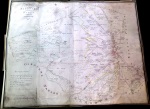
 As a first step to recording field names at various times in the history of the village we have taken the field names, boundaries and other features from the 1809 enclosure map and created a Google Map with layers showing these features.
There is more detail on the 1809 map than is easy to transcribe onto the Google Map, so areas within Upham, Snap and Aldbourne Villages have not been transcribed.
Currently there are three layers :
- field boundaries with either the field name or owners name (whichever was shown on the map)
- coloured blocks as shown on the map
- Other features such as place names, or features such as chalk pits or ponds
In time we will add other layers for field names as recorded more recently.
In creating this map it was interesting to see how many fields still exist in the same form, and even for those that don’t how some of their boundaries show as soilmarks on the aerial photography. Some of the field on the original map had the number of acres marked, and these often match very well to the area calculated by Google, and where they don’t the difference is probably more down to a transcription error on my part!
For me, the best field name so far is “Moonlight Corner”
